
Moving to Sedona AZ: What You Need to Know in 2026
Sedona’s red rock cliffs, pine forests, and small-town scale make moving to Sedona AZ a distinctive decision rather than a typical relocation. According to City of Sedona data, the city attracts about 3,000,000 visitors each year, a number that shapes traffic, job opportunities, and quality-of-life choices. Understanding neighborhoods from Uptown Sedona to West Sedona, as well as housing costs, schools, climate, and infrastructure in 2026, helps future residents align expectations with daily realities.
How Does Sedona’s Housing Market Look for 2026 Moves?
Housing in Sedona centers around single-family homes in West Sedona, townhomes near State Route 89A, and luxury properties surrounding Chapel Hill Drive. According to Redfin data through early 2026, typical closed-sale prices for standard single-family homes often fall between $750,000 and $1,100,000, with smaller condos in pockets near Tlaquepaque Arts & Shopping Village trading in the range of $450,000 to $650,000. Luxury listings in areas like Back O’ Beyond Road frequently surpass $2.4M, driven by panoramic red rock views.
Inventory remains limited compared with larger Arizona markets. Based on early 2026 tracking by Realtor.com, Sedona often carries fewer than 120 active residential listings at any given time, which supports steady price resilience even when statewide numbers soften. Newer subdivisions around Thunder Mountain Road and Soldiers Pass Road emphasize energy-efficient construction, while older ranch-style homes along Coffee Pot Drive offer wider lots and mature trees that appeal to long-term residents.
In the late afternoon, the streets around Tlaquepaque Arts & Shopping Village glow deep orange as the sun hits the sandstone walls, and the scent of roasting chiles from El Rincon Restaurant mixes with juniper on the breeze. Footsteps echo softly over the cobblestones while live guitar drifts from a small courtyard near Oak Creek, giving the surrounding casitas along Brewer Road a tranquil, almost secluded feel despite the steady murmur of visitors and gallery traffic.
Which Neighborhoods in Sedona Fit Different Lifestyles?
Different pockets of Sedona function almost like separate towns. Uptown Sedona, centered along North State Route 89A, concentrates galleries, tour operators, and restaurants like Hudson and Wildflower Bread Company. According to Walk Score, central Sedona posts scores in the low 30s, reflecting partial walkability but continued dependence on cars. Residents in Uptown accept heavier tourist traffic in exchange for short walks to shops, Oak Creek views from Schnebly Hill Road, and quick access to trailheads above Jordan Road.
West Sedona suits residents prioritizing services and everyday convenience. Grocery options along West State Route 89A include Safeway, Natural Grocers, and Whole Foods Market Sedona, while entertainment and sports programming cluster near Posse Grounds Park and the Sedona Performing Arts Center. According to neighborhood profiles on Niche, West Sedona offers a broader mix of housing built between the 1970s and early 2000s, creating price diversity that attracts both retirees and younger households seeking year-round community.
Village of Oak Creek, just south along State Route 179, lies in unincorporated Yavapai County but functions as part of the greater Sedona living area. It provides golf-course communities around Oakcreek Country Club and Sedona Golf Resort, as well as townhomes along Bell Rock Boulevard. Distances to Bell Rock and Courthouse Butte trailheads measure less than 2 miles from many streets, which appeals to residents who prefer quieter evenings than those common near Uptown’s tourist corridors.
What Should New Residents Know About Jobs, Costs, and Taxes?
Employment in Sedona leans heavily on tourism, hospitality, wellness, and small-scale professional services. According to the U.S. Bureau of Labor Statistics, the broader Flagstaff-Sedona region records unemployment rates generally hovering between 3% and 5% in recent years, slightly below some national averages. Many Sedona residents commute along State Route 89A or Interstate 17 to positions in Cottonwood, Camp Verde, and Flagstaff, a distance of roughly 30 to 50 miles depending on the destination.
Overall living costs run higher than many other Arizona communities. According to cost-of-living comparisons from BestPlaces, Sedona’s composite cost index scores around 140 on a national baseline of 100, with housing as the primary driver. Renters tracking data from RentCafe will see average advertised apartment rents tending to fall between $1,900 and $2,300 per month as of late 2025, depending on square footage and proximity to Uptown attractions or Oak Creek Canyon.
On a busy evening near Sunset Drive and Andante Drive, kitchen exhaust from local cafes drifts into the cool air, carrying aromas of garlic, basil, and mesquite smoke toward side streets lined with adobe homes. The hum of traffic along West State Route 89A blends with clinking glasses on patios, while porch lights flicker to life one by one. Residents returning from shifts at resorts in Oak Creek Canyon step onto gravel driveways, brushing red dust from shoes before the desert chill settles over the neighborhood.
How Are Schools, Parks, and Daily Services Structured?
Sedona’s education system centers on Sedona-Oak Creek Unified School District. According to GreatSchools, Sedona Red Rock High School holds ratings in the 7-to-8-out-of-10 range, while West Sedona School offers K-8 instruction near Posse Grounds Park. The district also operates Sedona Red Rock Junior High on Upper Red Rock Loop Road. Nearby, Yavapai College’s Sedona Center on Cultural Park Place provides culinary and arts programs, creating a local postsecondary option without requiring a daily commute to Prescott or Flagstaff.
Recreation opportunities spread across several city parks and federal lands. Posse Grounds Park, adjacent to Posse Ground Road, features sports fields, a skatepark, and the Sedona Community Pool. Sunset Park, off Shelby Drive, offers playgrounds and basketball courts. According to the Coconino National Forest, more than 1.8 million acres surround Sedona, with trailheads to Cathedral Rock, Bell Rock, and Boynton Canyon situated within roughly 5 to 15 miles of most residential streets, supporting year-round hiking and mountain biking.
Healthcare access centers around Verde Valley Medical Center – Sedona Campus on Posse Ground Road and multiple clinics along West State Route 89A. Essential retail includes Bashas’ Sedona on Highway 179, Walgreens near Dry Creek Road, and local shops concentrated in Hillside Sedona Shopping Center. The Sedona Public Library, located off White Bear Road, hosts community programming and provides free internet access, an important resource for remote workers or residents in areas where broadband coverage remains inconsistent.
What Climate, Traffic, and Infrastructure Factors Affect Daily Life?
Sedona’s high-desert climate offers four distinct seasons without Phoenix-level heat. According to National Weather Service Flagstaff data, average July highs in Sedona reach the mid-90s Fahrenheit, while January lows typically fall into the upper 20s to low 30s. Annual precipitation averages around 19 inches, with late summer monsoon storms bringing short, intense downpours that can temporarily affect low-lying crossings along Oak Creek and portions of State Route 179.
Traffic patterns shift significantly with tourism surges. The City of Sedona Transportation Department reports that weekend and holiday volumes on State Routes 89A and 179 increase travel times between Uptown and Village of Oak Creek by 15 to 30 minutes during peak hours. Roundabouts at key intersections such as Chapel Road and Bell Rock Boulevard help maintain flow, but residents planning regular commuting often favor West Sedona streets like Arroyo Pinon Drive and Rodeo Road for alternate access to main corridors.
Public transit options remain limited, although the Sedona Shuttle now connects key trailheads near Cathedral Rock, Soldier Pass, and Dry Creek Vista, reducing parking pressure in residential zones. Broadband coverage varies by subdivision; some streets near Airport Mesa and Upper Red Rock Loop Road rely on fixed wireless rather than fiber. Cell reception generally stays strong along major corridors but can weaken in deeper sections of Oak Creek Canyon, a consideration for residents who depend heavily on mobile connectivity for work.
The 3,000,000-visitor figure cited at the start of this guide reflects how a relatively small desert city now operates on a tourism scale that rivals larger metro destinations. That same visitor volume underscores why traffic, housing costs, and trail access need structured planning from incoming residents. The City of Sedona website offers current details on transportation projects, development applications, and community events that influence neighborhood decision-making. Prospective residents who monitor listings weekly and schedule in-person tours before the late-spring surge in May typically secure stronger contract terms; those waiting until after summer often confront tighter inventory, firmer pricing, and fewer choices across West Sedona, Uptown Sedona, and Village of Oak Creek.
FROM OUR BLOG
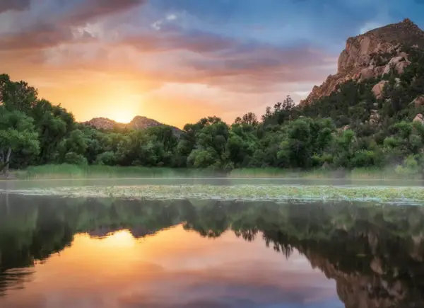
Top 10 Hiking Trails in Prescott: Adventure for Every Explorer
Top 10 Hiking Trails in Prescott: Adventure for Every Explorer Prescott, Arizona, is a hiker’s paradise, offering a diverse landscape of granite boulders, pine forests, and shimmering lakes. Whether you’re a seasoned adventurer or just looking for a family outing, Prescott’s trails have something fo

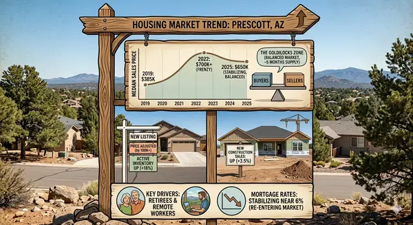
Prescott, Arizona Real Estate Market Trends: What Buyers and Sellers Need to Know in 2026
Prescott, Arizona Real Estate Market Trends: What Buyers and Sellers Need to Know in 2026 Nestled among rolling hills and pine forests, Prescott, Arizona, has always had a charm that draws both longtime residents and newcomers seeking a unique blend of small-town warmth and outdoor adventure. But la
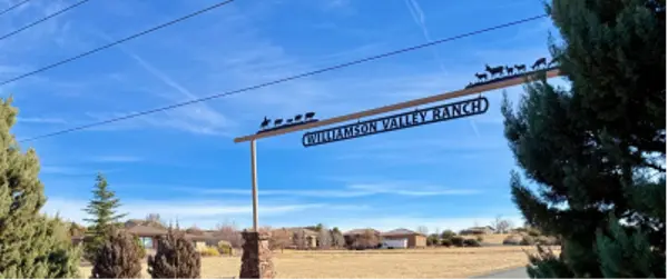
Popular Neighborhoods in Williamson Valley Ranch, Prescott, AZ
Popular Areas to Live in Williamson Valley Ranch Williamson Valley Ranch in Prescott, AZ, is renowned for its spacious properties and scenic vistas. But which areas stand out for homebuyers? Key Neighborhoods The community features several sought-after enclaves with custom homes, horse properties, a